DAATSim: Depth-Aware Atmospheric Turbulence Simulation
Overview
DAATSim is a depth-aware atmospheric turbulence simulator designed for fast image rendering under long-range imaging conditions. The system models spatially varying blur, depth-dependent distortion, and temporal consistency, producing realistic turbulence effects that are much closer to real-world behavior than uniform-blur approximations. The work was published in Pacific Graphics 2025 and highlights my broader research interest in combining physics-aware modeling with modern vision systems.
Motivation
Atmospheric turbulence affects distant objects more strongly than nearby structure, yet many simulators apply the same degradation everywhere in the image. This oversimplifies the problem and limits the usefulness of synthetic data for restoration, detection, and tracking tasks. DAATSim addresses this gap by explicitly incorporating depth into the simulation process, enabling more realistic rendering for surveillance, remote sensing, robotics, and long-range vision research.
Methodology
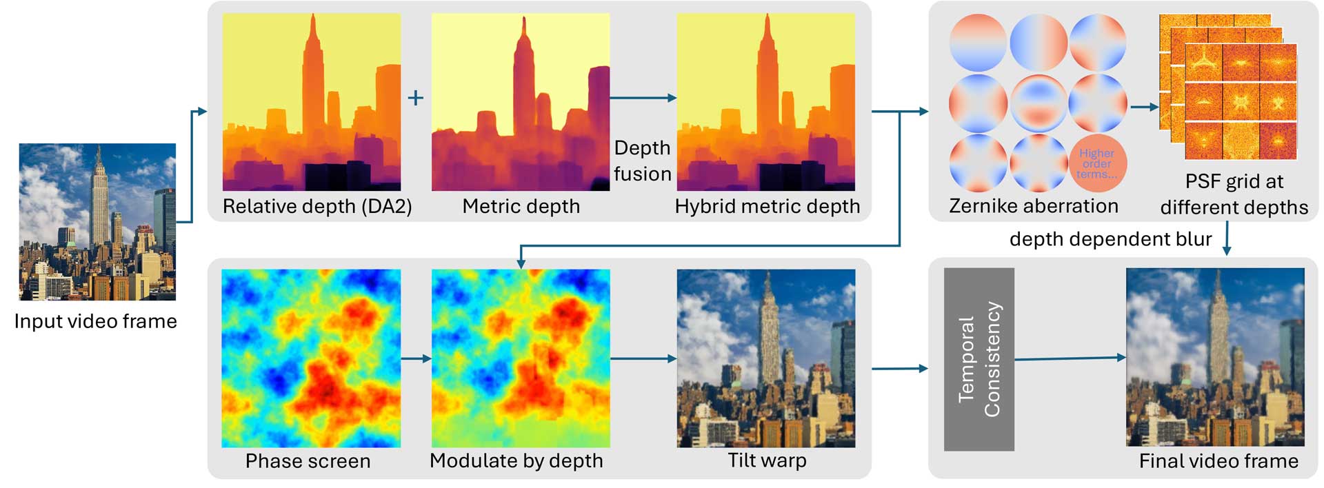
The method combines learned depth estimation with physically inspired turbulence simulation. Relative depth and metric depth cues are fused to build a scene-aware depth representation. That depth is then used to control tilt distortion, blur strength, and temporal evolution over a sequence, allowing the simulator to preserve foreground detail while appropriately degrading distant objects. The result is a controllable pipeline for generating realistic turbulence effects across both images and videos.
Why It Matters
Simulation is a critical part of restoration research because high-quality paired real data is difficult to capture at scale. By making turbulence depth-aware and temporally coherent, DAATSim creates more realistic synthetic examples for algorithm development and evaluation. This strengthens downstream work in restoration, segmentation, and long-range scene understanding, and helps bridge the gap between laboratory assumptions and operational imaging systems.
Research Outcome
DAATSim complements my restoration work by addressing the data and evaluation side of atmospheric imaging. Together with projects such as Turb-Seg-Res and structure index estimation, it contributes to a fuller research program around turbulence-aware imaging: simulation, estimation, segmentation, and restoration. The project is available through its dedicated website and published paper, making it one of the most complete public-facing entries in my recent research portfolio.